Showing posts with label gnome maps. Show all posts

Wednesday, March 12, 2025

Maps and GNOME 48


In a few days it's time for the GNOME 48 release.

So it's time to make a wrap-up with the last changes in Maps for the next release.

 Redesigned Route Markers

One issue that has been addressed was that the old markers we used to mark the start and end locations for routes, being filled and hollow circle icons respectively could be hard to tell apart and actually see which is which.
 
So now to mark the start we show a marker containing the icon representing the mode of transportation.


 The “walk” icon is also used for start of “walking legs” in public transit iteneraries, so this way it's getting a more consistent look.
 

 Redesigned User Location Marker

This was already covered in an earlier blog post, but it might be worth mentioning especially now that we once again have WiFi- and Celltower-based positioning again thanks to BeaconDB (it's already enabled by default in Fedora 41, and I think some other distros as well). We now have the redesigned location marker, using the system accent color.


Transitous Public Transit Routing Migrated to new API

Furthermore the Transitous support has been migrated to the MOTIS 2-based API. This has also been backported to the 47.x releases (as the old API has been retired).
Also public transit routing in Finland will start using Transitous from 48. As Digitransit has slated the retirement of their old OpenTripPlanner 1.x-based API from late April it seemed appropriate to start using Transitous for that region now.
 

Transitous Talk at FOSDEM 2025

When mentioning Transitous I also want to mention that the recording of mine, Felix Gündling's, and Jonah Brüchert's FOSDEM talk around Transitous is now available at:
 

So, please enjoy this, and all the other improvements in GNOME 48 when you grab it! 😎

Saturday, May 11, 2024

May Maps


It's about time for the spring update of goings on in Maps!

There's been some changes going on since the release of 46.


Vector Map by Default

The vector map is now being used by default, and with it Maps supports dark mode (also the old raster tiles has been retired, though there still exists the hidden feature of running with a local tile directory. Which was never really intended for general use but more as a way to experiment with offline map support). The plan will be to eventually support proper offline map support with a way to download areas in a more user-friendly and organized way then to provide a raw path…).

Dark Improvements

Following the introduction of dark map support the default rendering of public transit routes and lines has been improved for the dark mode to give better contrast (something that trickier before when the map view was always light even when the rest of the UI, such as the sidebar itinerary was shown in dark mode).


More Transit Mode Icons

Jakub Steiner and Sam Hewitt has been working on designing icons for some additional modes of transit, such as trolley buses, taxi, and monorail.

Trolley bus routes

This screenshot was something I “mocked” by changing the icon for regular bus to temporarily use the newly designed trolley bus icon as we don't currently have any supported transit route provider in Maps currently that exposed trolley bus routes. I originally made this for an excursion with a vintage trolley bus I was going to attend, but that was cancelled in the last minute because of technical issues.

Showing a taxi station

And above we have the new taxi icon (this could be used both for showing on-demand communal taxi transit and for taxi stations on the map.

These icons have not yet been merged into Maps, as there's still some work going on finalizing their design. But I thought I still wanted to show them here…

Brand Logos

For a long time we have shown a title image from Wikidata or Wikipedia for places when available. Now we show a logo image (using the Wikidata reference for the brand of a venue) when available, and the place has no dedicated article).

Explaining Place Types

As sometimes it can be a bit hard to determine the exact type from the icons shown on the map. And especially for more generic types, such as shops where we have dedicated icons for some, and a generic icon. We now show the type also in the place bubble (using the translations extracted from the iD OSM editor).


Places with a name shows the icon and type description below the name, dimmed.


For unnamed places we show the icon and type instead of the name, in the same bold style as the name would normally use.

Additional Things

Another detail worth mentioning is that you can now clear the currently showing route from the context menu so you won't have to open the sidebar again and manually erase the filled in destinations.


Another improvement is that if you already enter a starting point with ”Route from Here“, or enter an address in the sidebar and then use the “Directions”  button from a place bubble, that starting point will now be used instead of the current location.

Besides this, also some old commented-out code was removed… but there's no screenshots of that, I'm afraid ☺

Friday, March 15, 2024

Maps and GNOME 46

It's that time again, a new GNOME release is just around the corner.

 The news in Maps for GNOME 46

A lot of the new things we've been working on for the 46 release has already been covered, but here is few recaps.
 

The new map style

The map style used for the vector-based, client-side rendered map which is still considered experimental in 46 has been switched over to our new “GNOME-themed” style, which also supports a dark mode (enabled when the global dark mode is enabled).


The vector map still needs to be explicitly enabled via the “layers menu” (the second headerbar button from the left). This also require the backing installation of libshumate to be built with vector renderer support (which is the case when using the Flatpak from Flathub, and also libshumate will default to building the vector renderer from the 1.2.0 release, so distributions should likely have it enabled in their 46 installations).

The current plan looks like we're leaning towards flipping it on by default after the 46 release, so by 47 it will probably mean the old raster tiles from openstreetmap.org will be retired.

Also icons on the map (such as POIs) are now directly clickable. And labels should be localized to the user's language (when the appropriate language tags are available in the OpenStreetMap data).


Other visual improvements

For 46 the zoom control buttons has been revamped (again), and put in the lower corner (as also shown in the above screenshots):


The pin used to marked places selected from search results, and other things like pin-pointed locations in GeoJSON files has gained a new modernized design by Jakub Steiner.


The dialog for adding an OpenStreetMap account to edit POIs gained a refresh sporting the new libadwaita dialog and widgets by Felipe Kinoshita.


Also information about which floor a place is located at is shown in the place bubbles when available. This can be useful to find your way around for example big shopping malls and the like (this was an idea that came when looking for a café in a galleria in Riga last summer…).


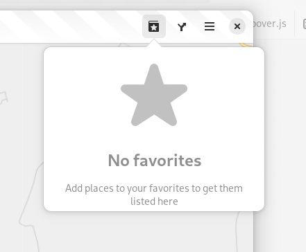
The favorites menu has also gotten a revamp. Instead of just showing a greyed-out inactive button when there's no favored places it now has an “empty state” hinting on the ability to “star” places.


And favorites can be removed directly from the list without having to open them (and animate to that place to show the bubble).


Looking further on

For the next cycle aside from continuing the refinements to the new map style and making the vector map the main thing another cool project that was initiated during FOSDEM in Februari has caught my attention:
 

Transitous

Transitous aims to setup a free and open public transit routing service: https://github.com/public-transport/transitous

It is using the MOTIS project (https://github.com/motis-project/motis) as the backend, with a cround sourcing approach to collect data feeds for timetable data.

The routing can already be tested out at https://transitous.org. Currently it only handles “station to station” routing, so there is not yet support for walking instructions.

Also, unlike the current public transit plugins support we have in Maps with Transitous you would also be able to cross-border planning (utilizing timetables from different data feeds).

When it becomes a bit more mature we should make use of it in Maps ☺.

So this another area to help out by creating PRs for adding transit schedule feeds for your local area that could potentially benefit both Maps and other FOSS projects (such as KDE Itinerary).

Problems ahead

And now to something of a problem.

The location service backend that we are using (not just used by Maps, but also other parts like Weather, automatic timezone handling) GeoClue has been using Mozilla's location service API (MLS). This will unfortunately be retired https://github.com/mozilla/ichnaea/issues/2065
 
So there will be a need to come up with alternative solutions https://gitlab.freedesktop.org/geoclue/geoclue/-/issues/186
 
Maybe in worst case, we'd have to disable showing current location in Maps unless the device has an actual GPS unit.
 

Wednesday, January 31, 2024

FOSDEMaps


It's only a couple of days left until that weekend of the week of the turn of month between January and February, and that means it's time again for FOSDEM, gathering FOSS entusiasts in Brussels, Belgium. And I will be there as well!

There has been some nice improvements in Maps since the end-of-year post before New Years as well.

James Westman has continued improving vector rendering support in libshumate and also implemented the ability to click on symbols, so you can finally click on labels and icons on the map instead of using the „What's here?” context menu item, doing a reverse geocoding. That always felt a bit like a „work around”. This seems like one of those cases of „a video says more than a thousand images”.

This is available when enabling the experimental vector map layer.


Another thing I have been working on is improving the experience of the favorites menu. Now instead of showing an insensitive, greye-out button in the headerbar when there are no places marked as favorites now the menu is always accessible, but instead shows an „empty state” when there are no places marked as favorites.

When there are places marked as favorites, there is now a close button next to the item allowing to remove it from favorites (rather than having to select the place and animate there to unmark the star icon in the popover showing).


When removing a favorite from menu a „toast” is displayed offering to undo this action (similar to when e.g. deleting files in Files).


Jakub Steiner has redesigned the map pin icon.


Compared to the old Tango-style icon that, while being a nice icon that has served us well looked a bit out-of-place in relation to the new UI style with a more 3D look.


Another new feature was thought up when looking for a cafe in a shopping mall in Riga during GUADEC last year is showing information about the floor location of places. There two established tags in OSM for this: level which represents the number of floors relative to the ground floor (or the lowest ground floor for buildings built in a souterrain fascion). In this case we now show this information in a spelled-out form for ground level or above, or below ground level (with provision for using localized plural forms).


The other tag is
level:ref referring a literal floor designation as „written in the elevator“. This could be fully spelled-out named floors, or numbers with suffixes and so on. When this is available we'll refer to that one as this would directly correspond to actual writing on-site.


Lastly James has added support for showing descriptions in the info bubble when clicking on points in a GeoJSON shape files when present. It also now shows the name of the shape file in the info bubble (this shape file was from an old GUADEC in Strasbourg).


Maybe I forgot something, but I think those where the highlights of new stuff so far in 2024.

Maybe see you in Brussels in a couple of days!

Friday, March 10, 2023

Maps and GNOME 44

 So it's that time that occurs twice a year when we're approaching a new GNOME release, this time 44.


In Maps there's been some polish touching up some of the rough edges in 43.x (from the GTK 4 port).

For example keyboard navigation of the search results is back.


Also, the focus handling of the entry is fixed so that the quirky flickering (re-popping up the the results popover when typing a space into the search entry) is now gone.

Also thanks to Christopher Davis for fixing up the styling of the results!

We also had contributions from an anonymous user improving the style of some labels, among others the tooltips of the headerbar buttons.


Adrien Plazas has worked on making the „Export as Image“ dialog fit on phones.


Unfortunately an issue has come to our attention with the way the „go to“ animations works, resulting some times when covering large distances (for example when selecting a search result far away) that results in throttling from the tile server (HTTP 429, „too many requests”). This results in empty tiles showing up at the destination (and one needs to sometimes wait a while before Maps gets the view refreshed with new tiles (after restarting to force re-trying).

 As this results in a really bad user experience as a work-around we have disabled the animations for now (the animations when zooming is still in place, and of course panning the map view still works as usual).

I also cherry-picked this for the 43 branch, and will probably also cut a 43.4 with this change (versions prior to 43.0 is not affected, as the animations in libchamplain uses another algorithm, first zooming out „high“ (a low zoom level) before moving, resulting in less intermediate tiles compared to the “fly to“-like animations now used in libshumate.

 We will try to come up with a better solution in libshumate soon. Either reverting to an approach like that in libchamplain, or try to implement our own rate limiting of some sort during animations to avoid firing off too many requests.

 Meanwhile at the libshumate side James Westman has been busy working on the vector tile support implementing label support among other things.

He is also working on a vector tile style using the GNOME color palette in light and dark variants.


This can be trying out on https://maps.jwestman.net/

 There will also be some other things coming for the next development cycle for GNOME 45, but let's save that for next time!

Thursday, December 29, 2022

Maps wrap-up 2022

 As I was quite busy during the days before Christmas this year I didn't get time to write the traditional holidays Maps blog post.

So I thought I should at least write a quick wrap-up of the happenings during 2022 before the end-of-year.

As always, we started out in spring with a new major release along the spring GNOME release (42.0).

In 42.0 (or rather during the development cycle leading up to it) Maps gained support for using the development profile, so that you can install nightly snapshot releases from the GNOME nightly Flatpak repo (or using locally-built bundles) in parallell with a stable release (using the Flathub release or from a „traditional“ distro package).


Like for other apps, the icon for the development release is distinguished by the „bio hazard stripe“.

Also in the 42.0 release, support for the maps: URI scheme was added. Using this a link can constructed that when opened will initiate a search using the encoded search term in Maps. This is now used by Contacts when a contact in the address book has an address set. There is also a DBus API for performing searches.

Later during spring, after the 42 release some additional spring cleaning was made.

Support for social media check-in was removed (and along with it the dependency on gnome-online-accounts). The one remaining implementation for Foursquare had not been working that reliably (and hasn't been widely used), and also the other implementation (for Facebook) had been removed one release before, and had been broken for a few years due to upstream API changes.

This was also done to get remove some mostly unused UI to get less code to port to GTK 4.

Another change was changing the process for performing OAuth setup for editing POIs in OpenStreetMap. Previously we had handled username and password locally and programmatically posted the OAuth authorization forms using a ported variant of the same code used by JOSM.

As this method is not really best-practice for doing OAuth sign-up, and this had already at one point been broken and needed fix due to changes on the server-side this was then rewritten to hand off the authorizing to use an external web browser.


   This has taken inspiration from how Cawbird implements signing in to Twitter.

Then in late June it became appearent that  due to other dependencies migrating to libsoup 3 (for HTTP request support) maintaining Maps using GTK 3, libchamplain (depending on libsoup 2.x) for GNOME 43 was looking impossible.

So, it seemed a last-minute port to use GTK 4 and our new libshumate map rendering library (based on the GTK 4 scene graph) should be attempted, even though the schedule was getting a bit tight…

But after some additional bumps (such as porting the OSM loging to use OAuth 2 due to needing to port to a new version of librest) and some frantic summer coding nights, just in time for GNOME 43 it was in working (good enough) condition.


Christopher Davis helped port the about window to use the new libadwaita version of the dialog. He also did some additional clean-ups after the GTK 4 port.

This release also involved settling on the API/ABI for libshumate and declare it as 1.0.0.

Following the release, I have also done some post-port mending to fix some brokenness left after the port.

Among the fixes, the „place bubbles“ has been fixed to get rid of the extraneous margin that unintentionally got there after the port (due to GtkPopover widgets behaving differently, they where special-cased in GTK 3 when it comes to applying the CSS spacing rules).

So after this fix the place image (when there is one) is now again „flush on“ with edge.

 This is available in the latest Maps release (43.2).

 James Westman has also been working on fixing some performance issues and memory leaks in libshumate (that has been backported to the 1.0 branch, currently the stable version released is 1.0.3).

James has also been continuing improving the vector tile support in libshumate.

I also took the time to implement one additional feature for the new major release (44.0).

Now Maps supports fetching the thumbnail and Wikipedia article extract when a place has a tag referring to an entry in Wikidata.

It is also now possible to edit those when editing a POI (and the Wikidata tag can be  „fetched“ semi-automatically when a Wikipedia article tag is filled in by pressing a reload button.


That's it for now. I said it was going to be a quick wrap-up, but I guess it got some length to it after all!

So, see ya in 2023 and happy new year!