I usually write a “Summer Maps” blog post around midsummer. It's a bit later this year. But here it comes!
Since the last time there has been some visual updates.
Search Bar Tweak
Since version 45 we had an “Explore POIs” interface that is accessed via a menu button next to the main search entry. This button used a linked style to get shared rounded corner. This has had some visual glitches when showing the search results popover (resutling in the rounded corner getting „straightened” giving jarred look).
After playing with putting the menu button at the side without being linked, but that gives a little „unbalanced” look with the popover. So I decided to try out something different.
Using the secondary icon of the entry, indicating the „explore” action when no search term is entered.
More Adwaita Dialogs
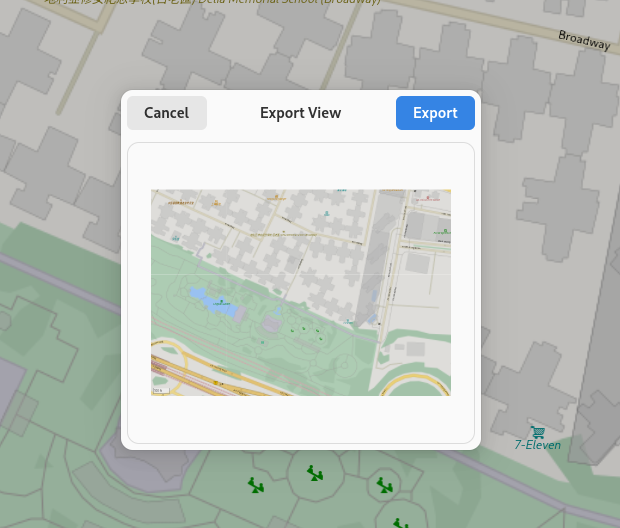
Contributor “DaPigGuy” has converted the export image dialog to use the new dialog widget from libadwaita. Also the save file UI has been streamlined, and is now handled by the file select dialog when clicking „Save”.
One more Icon
One additional POI icon for playgrounds has been contributed by Jakub Steiner.
 |
| Playgrounds |
Transitous Support
I've written about the Transitous project before.
There is now a work-in-progress branch implementing public transit routing using MOTIS: https://gitlab.gnome.org/GNOME/gnome-maps/-/merge_requests/440
Currently it works best when using the service at europe.motis-project.de.
This can be tested by setting the following environement variables when running the branch (from GNOME Builder it can be set either by entering the „execution terminal”, or by creating a custom run command).
TRANSITPLUGIN=Motis
MOTIS_BASE_URL=https://europe.motis-project.de
A sample of itineraries going from the Louvre to the Eiffel tower in Paris.
And I would like to re-iterate that you can also help contributing public transit feeds to the Transitous project for your locality by creating pull requests at https://github.com/public-transport/transitous
Hill Shading
Another project James Westman has been working on is hillshading. This would make the map show terrain topology, which not only gives the map a nicer, more live appearance. It is also beneficial for example when hiking.
Currently it awailable in the web preview for the map style at https://maps.jwestman.net/
In the screenshot above showing the Sylarna mountain range: Wikipedia
Contrasting with how it looks currently when rendered by libshumate in Maps
Adding this in libshumate will require some additional work, as it will need support for transparent „overlay sources” to render the „TopoRGB” tiles (which will basically be an alpha channel rendering „on top” of the vector rendering (I hope I explained that somewhat correctly).
And that's going to be it for this time!
And stay tuned 😀


No comments:
Post a Comment